Twentysix years ago, the world learned about the existence of the first imaging reconnaissance satellite, codenamed CORONA. It’s hard to imagine a world without Google maps or satellite imagery, but when CORONA was developed in the 1950s, satellite photo-reconnaissance didn’t exist.
CORONA was created by a small group of CIA, Air Force and private industry experts who were tasked with finding a way to provide broad imagery coverage of the USSR to identify missile launch sites and production facilities.
President Dwight D. Eisenhower formally endorsed CORONA in February 1958.
Known to the public as the U.S. Air Force’s Discoverer program, the classified CORONA project operated during the height of the Cold War to collect pictures over the denied areas of eastern Europe and Asia.
CORONA also had sister programs: ARGON for mapping imagery and LANYARD, a short-lived program designed for higher-quality imagery.
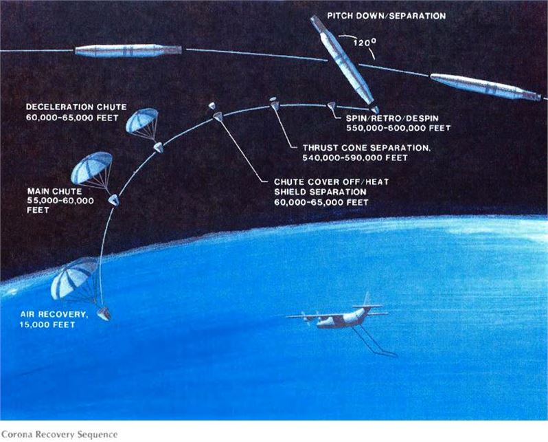
During its operational life, CORONA collected over 800,000 images in response to the national security requirements of the time. On average, individual images covered a geographic area on the Earth’s surface of approximately 10×120 miles.
On February 24, 1995, Vice President Gore visited CIA Headquarters to announce Executive Order 12951, signed by President Clinton, which released CORONA, ARGON, and LANYARD imagery to the public.
At the announcement, Gore stated, “Satellite coverage gave us the confidence to pursue arms control agreements–agreements that eventually led to dramatic decreases in the number of nuclear weapons and their delivery systems.”
Gore also noted that satellites, “Recorded much more than the landscape of the Cold War. In the process of acquiring this priceless data, we recorded for future generations the environmental history of the Earth at least a decade before any country on this Earth launched any Earth resource satellites.”
More than 800,000 photographs were sent over the following 18 months to the National Archives and the US Geological Survey. The order stipulated that all the imagery would be declassified immediately upon transfer and be made available to the public.
Thanks to the Intelligence Community’s persistence, CORONA resulted in one of the largest declassification projects in American history. The end of the Cold War also spurred interest in satellites and their possible use for environmental and other studies.
The full Intelligence Community archive of CORONA, ARGON, and LANYARD imagery has been transferred to the public archive at the National Archives and Records Administration (NARA) and the Earth Resources Observation Systems (EROS) Data Center. The NRO History Archive also contains a detailed collection of CORONA history, imagery and other related materials.
To learn more about the CORONA project, please see the following publications and video:
CORONA: America’s first Satellite Program (PDF — 18.43MB)
CORONA: The First Recovery of Film from Space
CORONA: Between the Sun and the Earth
DCI’s Address to CSI CORONA Symposium
CORONA and the Intelligence Community
CORONA video on CIA YouTube Channel
CIA-Produced 1995 film: A Point In Time
source: CIA FACTBOOK

EDITOR IN CHIEF